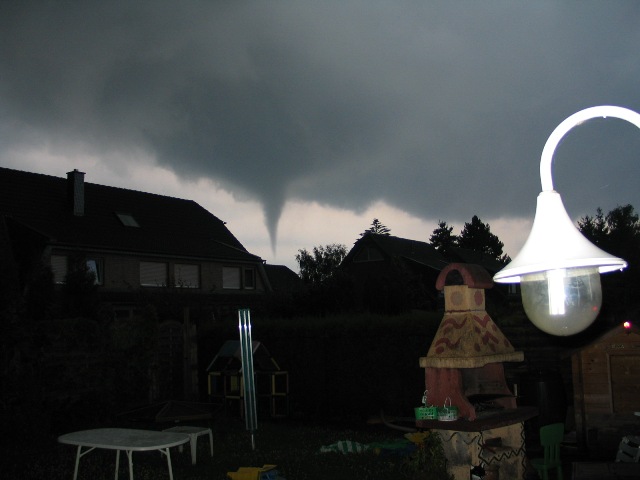
Cumulonimbus tuba
Cumulonimbus tuba Cb tub
Genus Cumulonimbus, Supplementary feature tuba
- Photo
- Volker Pingen
- Location
- Moers, Wesel
- Taken
- 18 July 2004, 21:03
In 2004, a tornado caused considerable damage over the Lower Rhine and western North Rhine-Westphalia. The city of Duisburg was also affected. This tornado with its funnel is very clearly visible. In cloud classification, this is referred to as a Cumulonimbus tuba.
The weather that day
Large-scale weather pattern
Disrupted bridge across central Europe BMz
The ridge over central Europe is broken by a low or an upper trough. Changeable but rarely very wet: stratocumulus and altocumulus, weakened fronts, and in summer a few showers and thunderstorms.
Typical clouds in this pattern: Stratocumulus, Altocumulus, Cumulus, Cumulonimbus
The weather pattern describes the flow over central Europe on that day – locally, the sky may have looked different.
The sky at nearby weather stations
In the photo: Cumulonimbus tuba · 21:00
As under “Identify”: ✓ = reported by a weather station, dots = estimated from height and cover (automatic measurement). The stations see their own sky – not necessarily the cloud in the photo.
Does the weather fit the cloud?
Cumulonimbus – according to the reanalysis quite possible (20:00) · Why?
- Reanalysis: 37 % low, 16 % middle, 95 % high cloud.
- In daytime thermals reach 400 m, the condensation level (dew-point spread 2.0 °C × 125 m) is at 250 m – rising air condenses.
- Plus 2.5 mm precipitation in the hour: the heap clouds grow tall enough to bring showers.
- A heavy shower (2.5 mm) in warm air: often from cumulonimbus. The reanalysis does not report thunder – hence only “quite possible”.
Formation: Thundercloud: a heap cloud grows to great heights in very unstable air; its summit glaciates (fibrous) and often spreads out as an anvil. Lightning, thunder, showers, hail.
Simplified rules applied to the ERA5 reanalysis for this day (grid point at the photo location, about 25 km grid spacing). The reanalysis only knows the cover per étage and values at the ground – the level is a rough estimate, not a measurement.
Also reported at nearby weather stations: Cumulonimbus
Measurements at the time of the photo
- Temperature
- 21.3 °C · Dew point 18.2 °C
- Humidity
- 83 %
- Wind
- from the south-east, 14 km/h (Beaufort 3)
- Precipitation
- 4.2 mm over the whole day
Rule of thumb for the base of heap clouds: about 400 m above the station (125 m per degree between temperature and dew point).
Sources: observations and measurements from Deutscher Wetterdienst, the German weather service (CC BY 4.0), Düsseldorf (20 km SE); weather pattern after Hess/Brezowsky from the DWD catalogue GWL-REA; ERA5 reanalysis by Copernicus/ECMWF (CC BY 4.0) via Open-Meteo. Times in local time.


Write a comment or ask a question about this photo
Every comment is read before it is published. Your email address is only needed for the confirmation link and a short message once the comment is online; it is deleted after that.