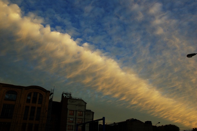
Stratocumulus radiatus Sc ra
Genus Stratocumulus, Variety radiatus
Also visible
Stratocumulus virga Sc vir
Genus Stratocumulus, Supplementary feature virga
Altocumulus Ac
Genus Altocumulus
- Photo
- Patric Seifert
- Location
- Chemnitz
- Taken
- 26 October 2009
A radiant arrangement of Stratocumulus, known as Stratocumulus radiatus. Below, virga can even be seen (Stratocumulus virga). Above, Altocumulus cloudiness.
The weather that day
Large-scale weather pattern
Anticyclonic westerly Wa
High pressure over southern Europe extends into central Europe while lows pass far to the north. Mostly dry, warm in summer and mild in winter; the north is sometimes brushed by cloud bands of decaying fronts.
Typical clouds in this pattern: Cumulus, Stratocumulus, Cirrus
The weather pattern describes the flow over central Europe on that day – locally, the sky may have looked different.
The sky at nearby weather stations
In the photo: Stratocumulus radiatus, Stratocumulus virga, Altocumulus
As under “Identify”: ✓ = reported by a weather station, dots = estimated from height and cover (automatic measurement). The stations see their own sky – not necessarily the cloud in the photo.
Does the weather fit the cloud?
Stratocumulus – observed at a weather station ✓ (Chemnitz · 6 km · 6:00) · Reanalysis quite possible · Why?
- Observation: An observer at the Chemnitz station (6 km, 6:00) reports Stratocumulus.
- Station measurement: Chemnitz (6 km, 5:00), likely: The instrument reports a layer at 1,250 m, 7/8 covered. The base lies well above the condensation level of surface air (about 100 m): not a thermal cloud but a layer – stratocumulus.
- Reanalysis (11:00), quite possible: 68 % low, 7 % middle, 0 % high cloud. In daytime thermals reach 650 m, the condensation level (dew-point spread 3.4 °C × 125 m) is at 450 m – rising air condenses. Low cloud 68 %: the heap clouds spread out beneath a stable layer into a deck.
Formation: Low layer of clumps or rolls beneath a stable layer (inversion). Forms through radiative cooling and mixing at the cloud top, or when heap clouds spread out under the inversion.
Altocumulus – observed at a weather station ✓ (Chemnitz · 6 km · 10:00) · Reanalysis quite possible · Why?
- Observation: An observer at the Chemnitz station (6 km, 10:00) reports Altocumulus.
- Reanalysis (12:00), quite possible: Middle cloud 27 %. Partly covered: middle cloud patches are usually altocumulus.
Formation: Layer at middle height (2–6 km), usually a few hundred metres thick. Radiative cooling at the top and mixing create small overturning cells – hence clumps, rolls and waves.
Observation before model: what an observer at a weather station reported counts for more than an estimate from a station’s instruments and more than the weather model. Each piece of information counts for less the farther away the station and the further from the time of the photo; the strongest comes first. The ERA5 reanalysis (grid point at the photo location, about 25 km grid spacing) only knows the cover per étage and values at the ground – its level is a rough estimate.
Measurements that day
- Temperature
- 6.4 to 12.2 °C
- Precipitation
- 1.1 mm over the whole day
Sources: observations and measurements from Deutscher Wetterdienst, the German weather service (CC BY 4.0), Chemnitz (6 km SW); weather pattern after Hess/Brezowsky from the DWD catalogue GWL-REA; ERA5 reanalysis by Copernicus/ECMWF (CC BY 4.0) via Open-Meteo. Times in local time.

Write a comment or ask a question about this photo
Every comment is read before it is published. Your email address is only needed for the confirmation link and a short message once the comment is online; it is deleted after that.