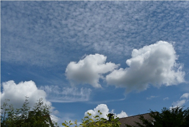
Cirrocumulus stratiformis lacunosus floccus, Cirrocumulus virga, Cumulus mediocris
Cirrocumulus stratiformis floccus lacunosus Cc str flo la
Genus Cirrocumulus, Species stratiformis, Species floccus, Variety lacunosus
Cirrocumulus virga Cc vir
Genus Cirrocumulus, Supplementary feature virga
- Photo
- Wilfried Mahr
- Location
- Darmstadt
- Taken
- 28 July 2009, 12:42
Two cloud families can be seen in this photo: 1. high clouds: An extensive field of Cirrocumulus stratiformis lacunosus floccus in the upper part of the photo. In the lower left quadrant, virga streaks of a Cirrocumulus virga are visible. 2. clouds with vertical development: so-called Cumulus mediocris clouds in the lower layers.
The weather that day
Large-scale weather pattern
Anticyclonic bridge across central Europe BMa
A ridge of high pressure links the Azores high with a high over eastern Europe. Similar to “High over central Europe”: fair-weather cumulus in summer, persistent fog and low stratus in winter.
Typical clouds in this pattern: Cumulus, Stratus, Stratocumulus, Cirrus
The weather pattern describes the flow over central Europe on that day – locally, the sky may have looked different.
Clouds at nearby weather stations
| Station | 6:00 | 9:00 | 12:00 | 13:00 · Photo | 15:00 | 18:00 | 21:00 |
|---|---|---|---|---|---|---|---|
| Frankfurt/Main20 km NW | Sc | Cu Ci | Cu Ci | Cu Ci | Cu | Cu | Sc Ci |
| Offenbach-Wetterpark26 km N | clear | clear | 7/8 · base 990 m | 5/8 · base 1,020 m | 3/8 · base 6,300 m | 6/8 · base 1,800 m | 1/8 · base 2,100 m |
Abbreviations = reported cloud genera, from low to high; grey = only cover in oktas and cloud base reported (automatic measurement or airport report). Each station sees its own sky – not necessarily the cloud in the photo.
Also reported at nearby weather stations: Cumulus
Measurements at the time of the photo
- Temperature
- 20.0 °C · Dew point 10.3 °C
- Humidity
- 54 %
- Wind
- from the south-west, 7 km/h (Beaufort 2)
- Precipitation
- none measured
Between 19:00 and 21:00 the temperature dropped by 4.8 °C.
Rule of thumb for the base of heap clouds: about 1,200 m above the station (125 m per degree between temperature and dew point).
Sources: observations and measurements from Deutscher Wetterdienst, the German weather service (CC BY 4.0), Darmstadt (2 km NE), Frankfurt/Main (20 km NW); weather pattern after Hess/Brezowsky from the DWD catalogue GWL-REA. Times in local time.

Write a comment or ask a question about this photo
Every comment is read before it is published. Your email address is only needed for the confirmation link and a short message once the comment is online; it is deleted after that.