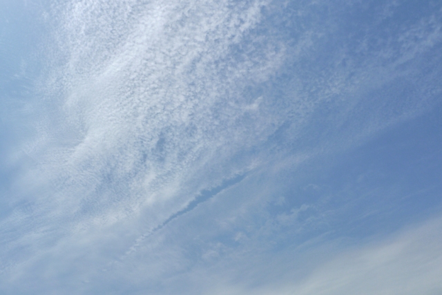
Cirrocumulus floccus lacunosus, Cirrostratus, Cirrus fibratus
Cirrocumulus floccus lacunosus Cc flo la
Genus Cirrocumulus, Species floccus, Variety lacunosus
Cirrostratus Cs
Genus Cirrostratus
- Photo
- Wilfried Mahr
- Location
- Darmstadt, Germany
- Taken
- 30 June 2012, 13:40
A photo showing a set of clouds from the family of high clouds. The grainy structure in the upper center of the image is Cirrocumulus floccus lacunosus. Just below it is thin Cirrostratus, and in the lower right, Cirrus fibratus.
The weather that day
Large-scale weather pattern
Disrupted bridge across central Europe BMz
The ridge over central Europe is broken by a low or an upper trough. Changeable but rarely very wet: stratocumulus and altocumulus, weakened fronts, and in summer a few showers and thunderstorms.
Typical clouds in this pattern: Stratocumulus, Altocumulus, Cumulus, Cumulonimbus
The weather pattern describes the flow over central Europe on that day – locally, the sky may have looked different.
The sky at nearby weather stations
In the photo: Cirrocumulus floccus lacunosus, Cirrostratus, Cirrus fibratus · 14:00
As under “Identify”: ✓ = reported by a weather station, dots = estimated from height and cover (automatic measurement). The stations see their own sky – not necessarily the cloud in the photo.
Does the weather fit the cloud?
Cirrostratus – according to the reanalysis possible (16:00) · Why?
- Where the fibres merge, a veil forms.
Formation: Ice veil, usually formed by slow large-scale lifting ahead of a warm front; as it thickens and lowers it turns into altostratus.
Cirrus – according to the reanalysis quite possible (15:00) · Why?
- Reanalysis: High cloud 21 %.
- High ice clouds, only partly covering the sky: cirrus.
Formation: Ice cloud at great height (usually above 6 km, below about −35 °C). Forms when moist air is lifted high up, or as left-over ice from convective clouds and contrails; falling crystals make the fibres.
Simplified rules applied to the ERA5 reanalysis for this day (grid point at the photo location, about 25 km grid spacing). The reanalysis only knows the cover per étage and values at the ground – the level is a rough estimate, not a measurement.
Measurements at the time of the photo
- Temperature
- 26.8 °C · Dew point 14.5 °C
- Humidity
- 47 %
- Wind
- from the south-west, 4 km/h (Beaufort 1)
- Precipitation
- 0.1 mm over the whole day
Sources: observations and measurements from Deutscher Wetterdienst, the German weather service (CC BY 4.0), Darmstadt (2 km NE), Frankfurt/Main (20 km NW); weather pattern after Hess/Brezowsky from the DWD catalogue GWL-REA; ERA5 reanalysis by Copernicus/ECMWF (CC BY 4.0) via Open-Meteo. Times in local time.

Write a comment or ask a question about this photo
Every comment is read before it is published. Your email address is only needed for the confirmation link and a short message once the comment is online; it is deleted after that.