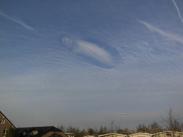
Hole Punch Cloud, Cirrocumulus stratiformis undulatus, Stratus
Cirrocumulus stratiformis undulatus Cc str un
Genus Cirrocumulus, Species stratiformis, Variety undulatus
Stratus St
Genus Stratus
Cirrocumulus cavum Cc cav
Genus Cirrocumulus, Supplementary feature cavum
Also visible: Hole punch cloud
- Photo
- Freddy
- Location
- Gronau, Germany
- Taken
- 17 April 2012, 07:31
A so-called Hole Punch Cloud forms when ice crystals fall through cloud layers and cause the cloud droplets to "freeze" onto the ice crystals. This creates a cloud hole, in the center of which the ice crystals accumulate. The falling ice crystals can be products from aircraft exhaust, as is likely the case in this image, since a contrail can be seen at the top left. In the middle part of the image, a Cirrocumulus stratiformis undulatus can be seen, below which there is an Altocumulus radiatus and at the very bottom above the horizon presumably a Stratus.
The weather that day
Large-scale weather pattern
Low over the British Isles TB
A low over the British Isles places central Europe on its front side in a south-westerly to southerly flow. Advancing cirrus and cirrostratus, then altostratus; warm in summer with thunderstorms ahead of the cold front.
Typical clouds in this pattern: Cirrus, Cirrostratus, Altostratus, Altocumulus, Cumulonimbus
The weather pattern describes the flow over central Europe on that day – locally, the sky may have looked different.
Clouds at nearby weather stations
| Station | 6:00 | 8:00 · Photo | 9:00 | 12:00 | 15:00 | 18:00 | 21:00 |
|---|---|---|---|---|---|---|---|
| Ahaus16 km S | clear | 6/8 · base 5,400 m | 7/8 · base 5,100 m | 5/8 · base 1,470 m | 8/8 · base 2,700 m | 7/8 · base 1,800 m | 7/8 · base 570 m |
| Rheine-Bentlage26 km E | Sc | Ac Ci | Ci | Cu Ac Cs | Cu Ac Cs | Sc Ac | Sc As |
| Lingen39 km NE | Sc | Ac Ci | Ac Ci | Cu As Ci | Cu Sc Ac | Sc As | Sc |
Abbreviations = reported cloud genera, from low to high; grey = only cover in oktas and cloud base reported (automatic measurement or airport report). Each station sees its own sky – not necessarily the cloud in the photo.
Measurements at the time of the photo
- Temperature
- 0.3 °C · Dew point -1.1 °C
- Humidity
- 90 %
- Wind
- from the south-east, 7 km/h (Beaufort 2)
- Precipitation
- none measured
Air pressure fell by 2.4 hPa in the three hours before the photo was taken.
Sources: observations and measurements from Deutscher Wetterdienst, the German weather service (CC BY 4.0), Ahaus (16 km S), Bentheim, Bad (12 km NE); weather pattern after Hess/Brezowsky from the DWD catalogue GWL-REA. Times in local time.


Write a comment or ask a question about this photo
Every comment is read before it is published. Your email address is only needed for the confirmation link and a short message once the comment is online; it is deleted after that.